![]()
![]()
The case study Milan and Water is a research project carried out as preparation of the Urban Agriculture Masterplan: Milan CPUL and the Urban Agriculture & Community Food Centre, Milan.
Unlike many of Europe’s great cities, Milan was not founded upon a major river course, making the city highly unique for one that has grown to become one of Europe’s largest metropolises. Located upon a saturated plain below the Alps, the city instead benefits from a naturally-high water table, only a few metres below ground level with which it is able to supply much of the city’s municipal waters.
Since the Roman occupation of the city, the hydraulic landscape of Milan (or Mediolanum, as it was then known) has undergone constant evolution, coinciding with an evolution in land use, changing city functions, territorial invasions, and industrial expansions, all of which have altered how the city’s waterways have been utilised. From a seemingly homogeneous natural water landscape upon an elevated plain cut only periodically by a few minor rivers, Milan has been transformed with help of a complex network of canals, locks and irrigation ditches which proved essential in propelling Milan into a position of economic, industrial and commercial importance in the region.

Despite experiencing a mild climate throughout much of the year, Milan’s position upon an elevated plain with an abundance of groundwater means that the city tends to experience high humidity throughout, as a result of a lack of wind to provide ventilation for the city. Although fairly consistent throughout the year, the greatest humidity is experienced between October and January, unusually when the temperature is lowest. Milan regularly experiences thick fog during these winter months, especially around the fringes of the city nearest the South Agricultural Park.
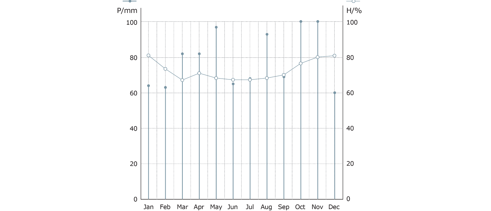
MIlan Humidity & Rainfall Graph
Precipitation, unlike humidity fluctuates greatly throughout the year with the highest rainfall generally experience in late autumn time (October) , and the lowest during the coldest winter months (January). Rainfall in Milan tends to obey two annual cycles, with the first taking place in the early summertime (May), followed by a dry June and July, followed once again by a period of extended fall between August and November, and a relatively dry spell between December and February.
Unlike many of Europe’s great cities, Milan was not founded upon a major river course, making the city highly unique for one that has grown to become one of Europe’s largest metropolises. Located upon a saturated plain below the Alps, the city instead benefits from a naturally-high water table, only a few metres below ground level with which it is able to supply much of the city’s municipal waters.
Since the Roman occupation of the city, the hydraulic landscape of Milan (or Mediolanum, as it was then known) has undergone constant evolution, coinciding with an evolution in land use, changing city functions, territorial invasions, and industrial expansions, all of which have altered how the city’s waterways have been utilised. From a seemingly homogeneous natural water landscape upon an elevated plain cut only periodically by a few minor rivers, Milan has been transformed with help of a complex network of canals, locks and irrigation ditches which proved essential in propelling Milan into a position of economic, industrial and commercial importance in the region.

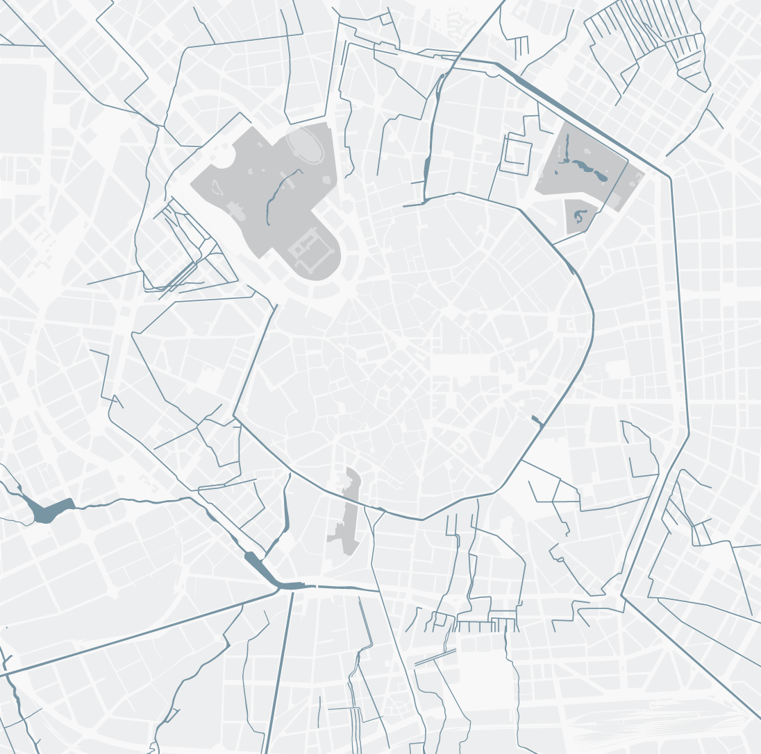
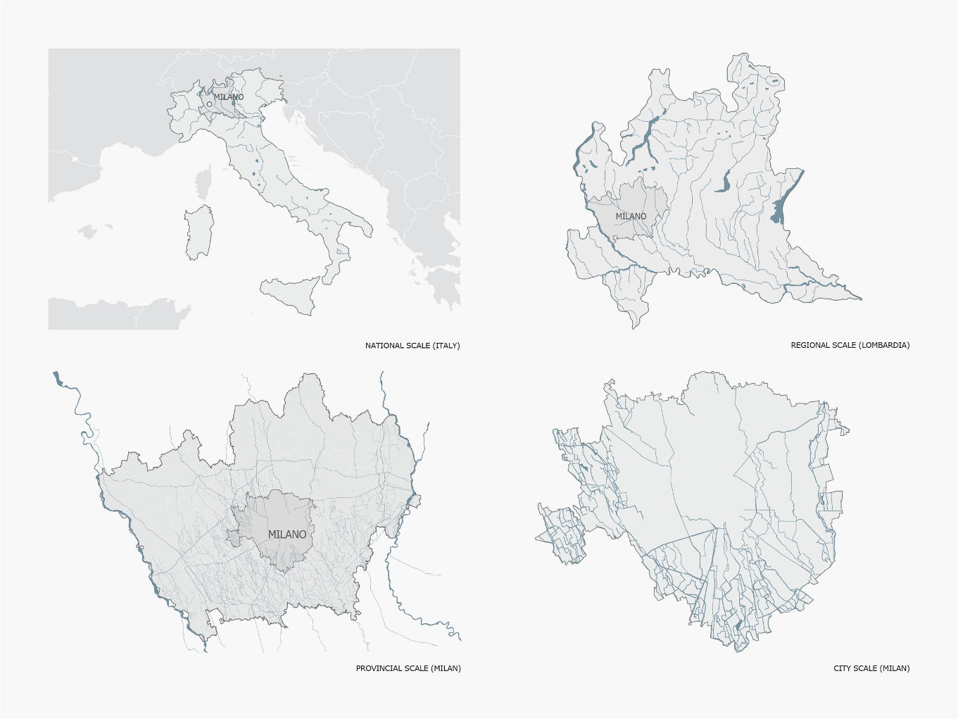
Milan Water Maps | Region, Province, City
It is well-documented that the first large-scale transformation Milan’s waterways began during the Twelfth Century, although the history of Milan’s hydraulic work dates back centuries before.
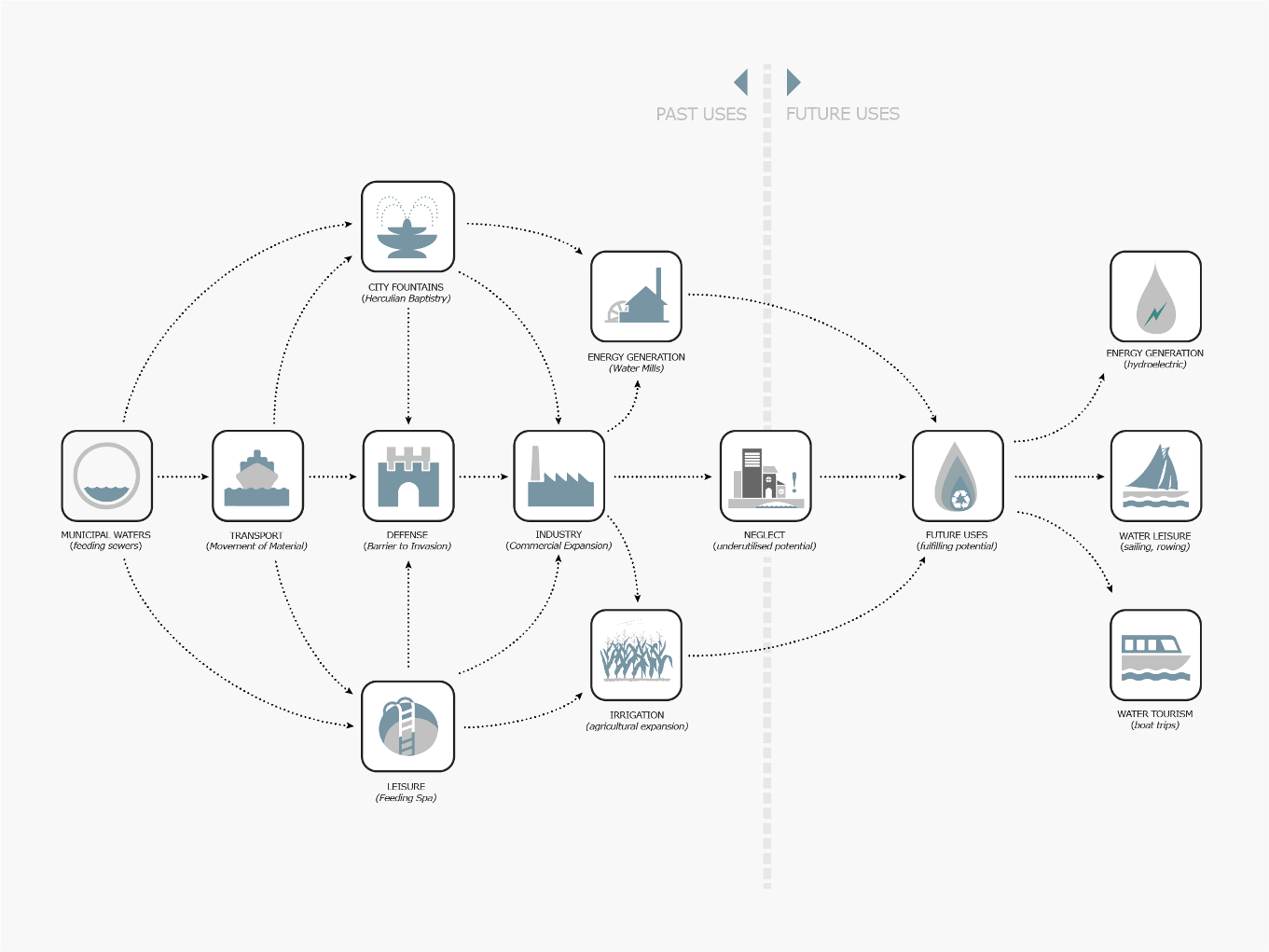
The first recorded hydraulic works undertaken by the Romans saw the diversion of the Seveso River, along new lines for the dual purpose of feeding the city’s newly-engineered sewer system, and providing a line of defence around the city walls. Once a sustained water supply had been established, the city was able to provide for public amenities, such as the Herculean Baptistry, public baths or spas.
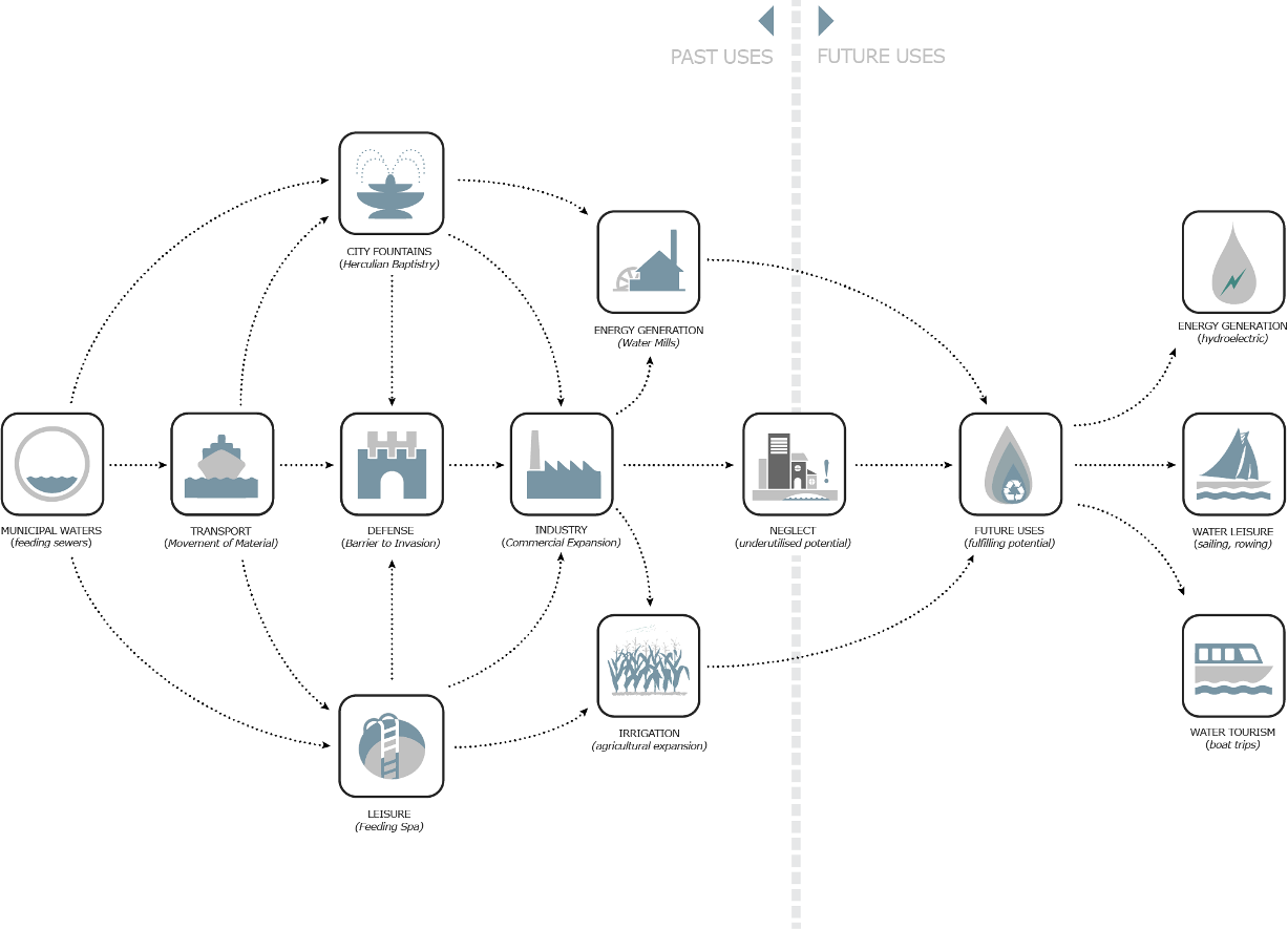
Evolution of Water Use in Milan
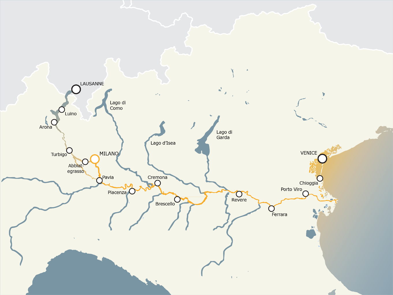
The greatest hydraulic engineering works took place during the twelfth century with an ambitious plan to bring the waters of the Ticino over 40km to the city gates. The then newly-established link to the Ticino via the Naviglio Grande enabled connections to the neighbouring economic centres of Pavia, and Piacenza, and east via the Po rover to the major cities of Venice and Ferrara, and the Adriatic Sea.
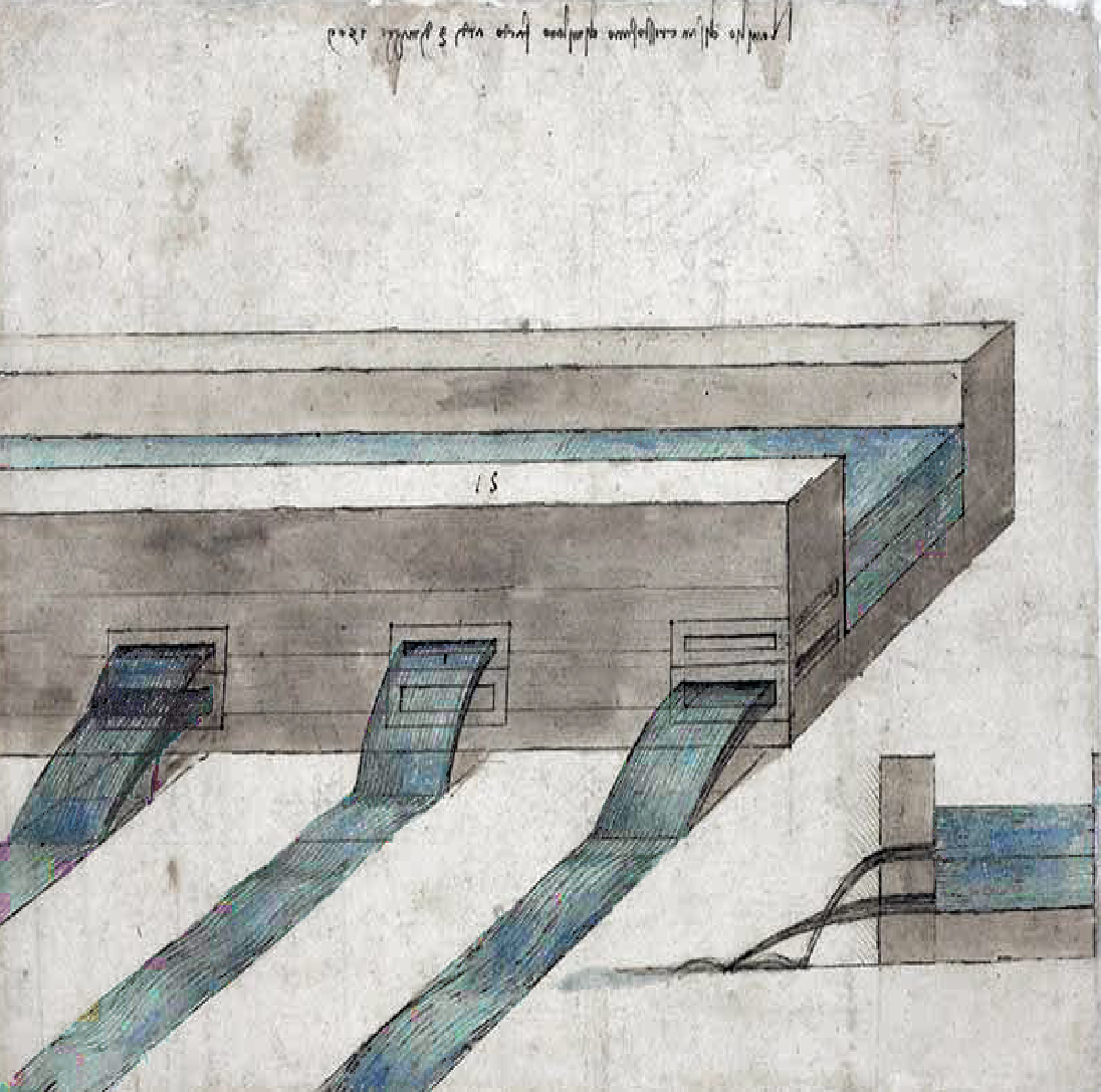
By the turn of the Sixteenth Century, Milan was in direct contact with both the Adda and Ticino, providing direct links to the Po River and the Adriatic Sea, and stimulating trade between Milan and the rest of the World. Much of the work carried out prior to the construction of the Cerchia di Navigli, or the Circle of Canals can be attributed to the contributions of Leonardo da Vinci. In addition to devising a means to overcome the vertical distance needed to connect the two disparate canal systems, was the one to initially propose bringing the waters of the Martesana to the northeastern edge of the city, to feed city canal system.
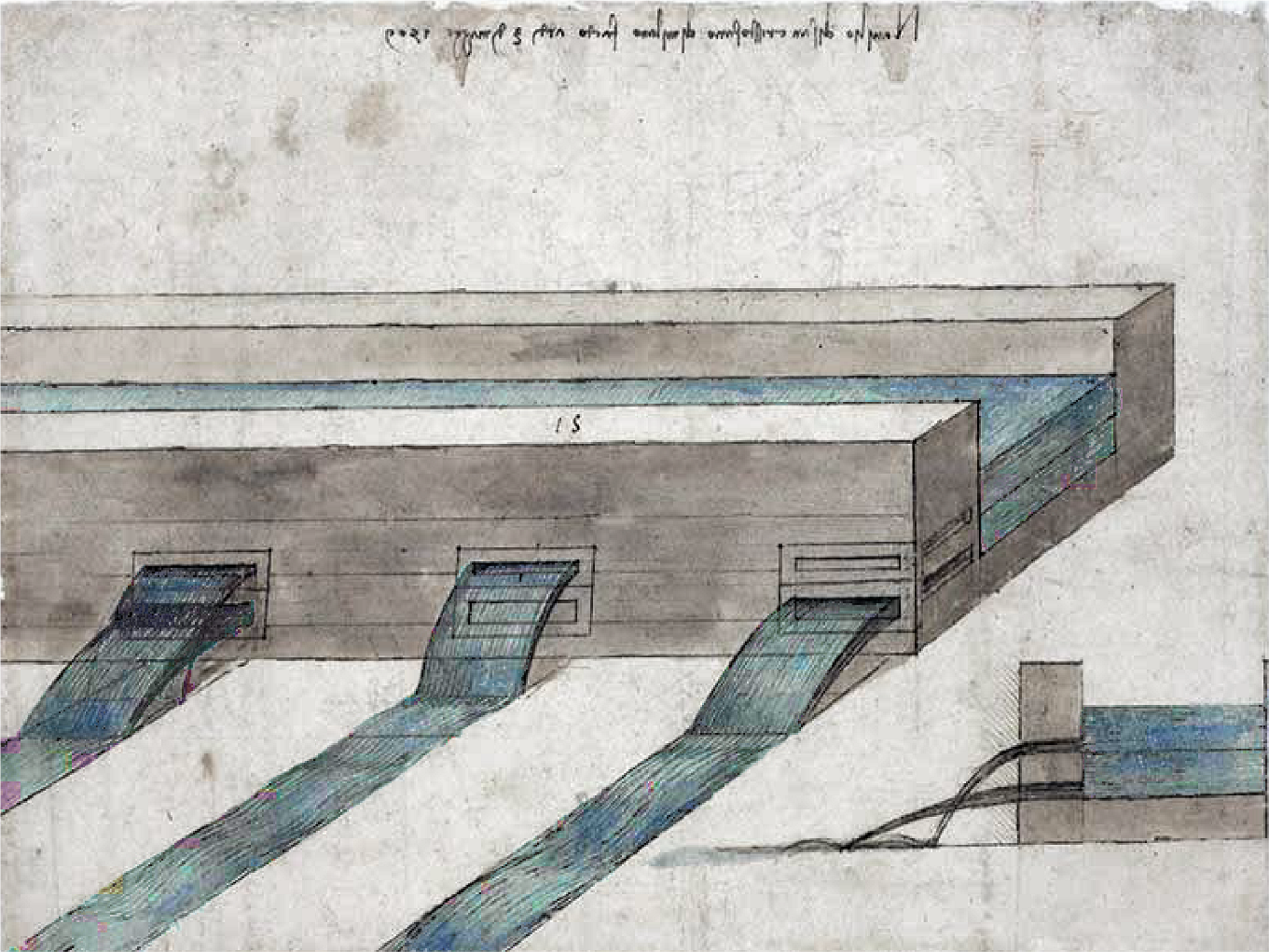
Leonardo da Vinci Drawing | Milan’s Canal-Fed Irrigation System
The construction of the main canal network, some of which we can still see today, served a dual purpose as a method of transporting goods for trade and city construction, and also setting up a series of obstacles to resist a likely invasion from Milan’s neighbouring provinces.
With the readily-available surface waters of the Naviglio Grande, the Milanese were able to flood the landscape at will, enabling the first cultivation of rice in Europe following its discovery from the East. A huge network of irrigation channels spread south from the Naviglio Grande, changing the landscape forever. The channels, still visible today, define Milan’s agricultural area, symbolising the
city’s historical control of the surrounding landscape.
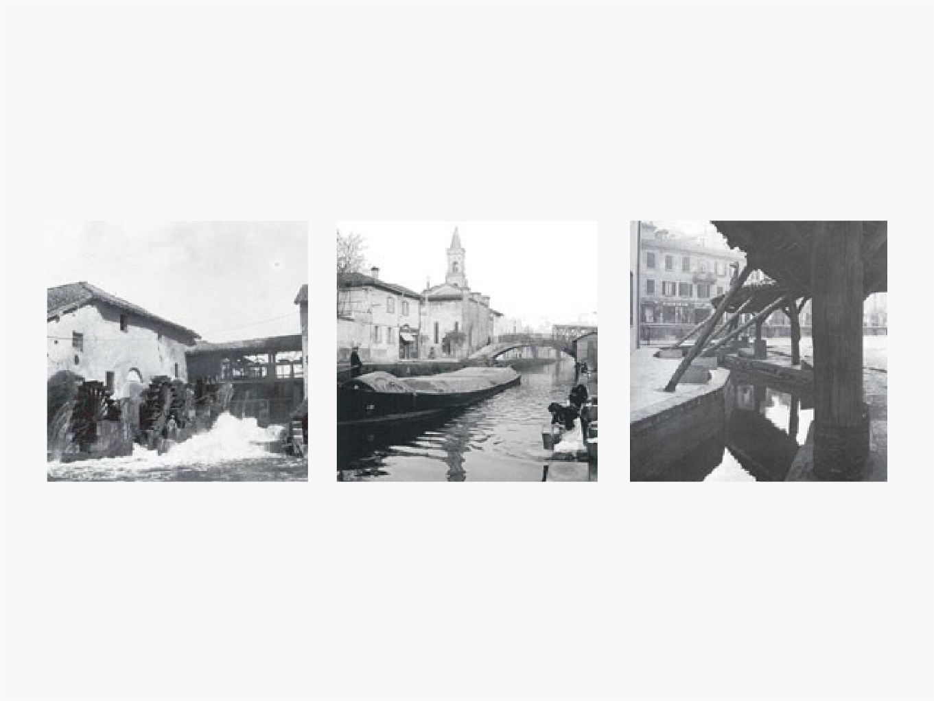
Throughout the 18th and 19th Century and into the start of the Industrial Revolution, the continued expansion of the canal and irrigation network secured Milan’s agricultural control over the landscape, where mills utilised the power of water to process food for the first time for export to the wider region.
During Milan’s industrial heyday, the ceramic and textile factories, which sprang up across the landscape, took advantage of the vast abundance of water to feed production.
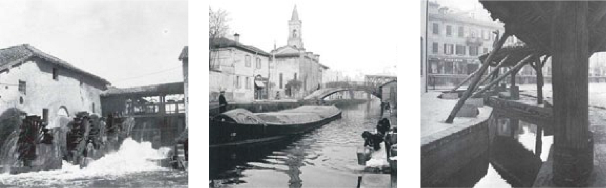
Historic Photos of Milan’s Waterways
During the latter half of the Twentieth Century, pressures on inner city land and a loss in function of the extensive urban canal network led to the systematic to the systematic dismantlement of the Milan’s inner city water network, its locks and canals, many being drained and covered to provide inner city highways to accommodate the increased use of private transport in the city. This included the iconic Cerchia di Navigli, or Circle of Canals, dating back to the 12th Century, which now forms the route of the inner city ring-road.
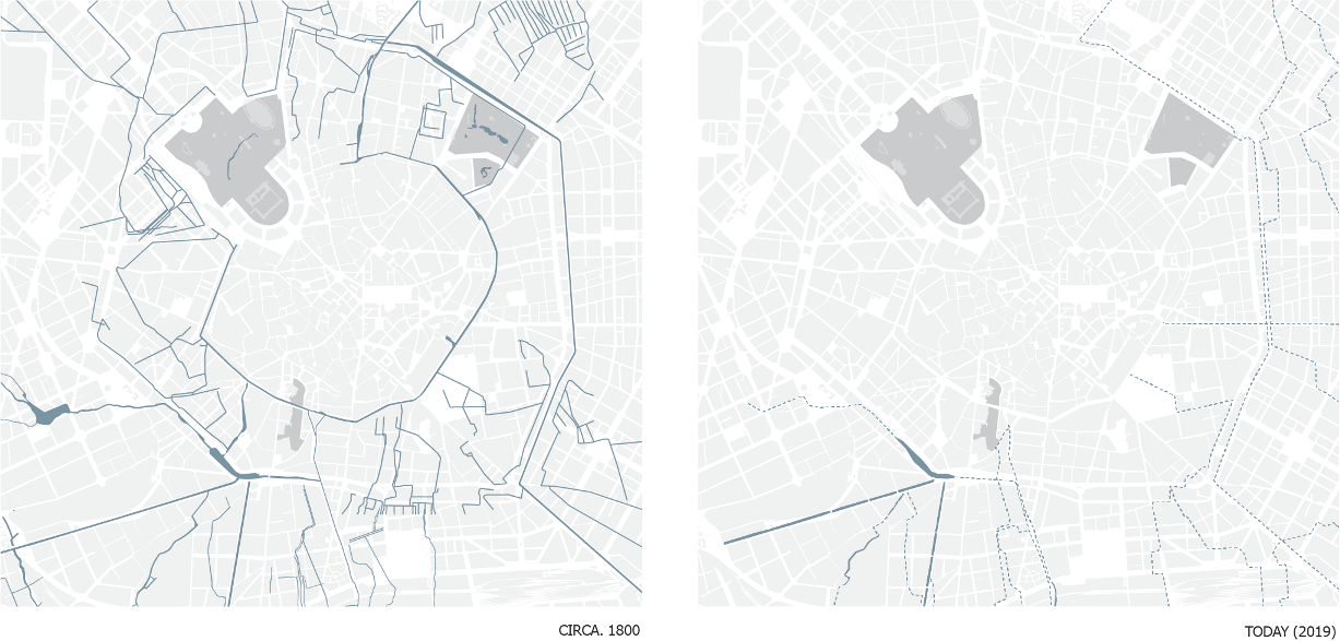
Transformation of Milan City Water Network (1800 & 2019)
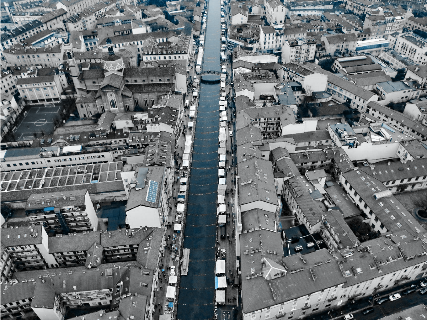
Fortunately, Milan still boasts the presence of the Naviglio Grande and Naviglio Pavese to the southwest of the city which still carries the waters of the Ticino to the Darsena Basin, in the southwest of the city centre. As one travels further out along the Naviglio Grande, much of the vast irrigation network supplied by the Naviglio Grande still remains, enabling large-scale rice farming just as it has done for centuries.
Throughout the 18th and 19th Century and into the start of the Industrial Revolution, the continued expansion of the canal and irrigation network secured Milan’s agricultural control over the landscape, where mills utilised the power of water to process food for the first time for export to the wider region.
During Milan’s industrial heyday, the ceramic and textile factories, which sprang up across the landscape, took advantage of the vast abundance of water to feed production.
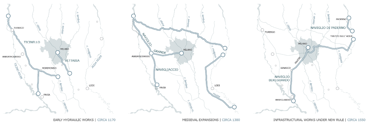
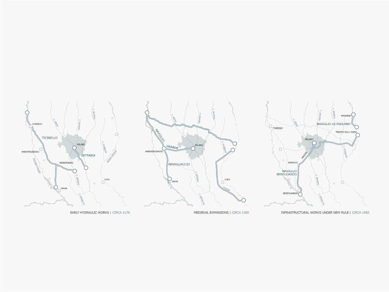
Milan’s Hydrological Expansion | Water Infrastructure Works [C12th-C19th]
Early Hydraulic Works | Circa 1170CE
In the latter half of the 12th century, under instruction from Emperor Frederick Barbarossa, work was begun on diverting part of the large Ticino River east towards the city in order to provide Milan with its own major watercourse, which it so desperately needed to aid expansion. By 1233, the new ‘Ticinello’ flowed from Turbigo south along a new route to Abbiategrasso, before travelling on to Morimondo and Pavia.
In order to handle to expected increases in the water flowing through the city, the new Vettabia was also dug to provide an efficient means of discharge for the waters of the diverted Seveso, Olona, and future planned waterways.
Medieval Expansions | Circa 1380CE
With the Vettabia completed, work could begin on the construction of the new branch of the Ticinello, which would later become the Naviglio Grande. The commencement of construction of the cathedral in 1386, requiring the movement of large amounts of lumber and stone, initiated a further widening of the Naviglio Grande to allow for larger vessel to navigate.
Around the same time, the Lodigiani of Lodi fearful of the aggression of the Milanese expansion construct a new stretch of waterway, branching off along the western side of the Adda river to provide a clear line of defence between the two cities.
Expansions Under New Rule | Circa 1550CE
Interruptions in the construction of the cathedral call for a new connection to be established between Milan and the Adda River, to facilitate the movement of vast amounts of marble from the shores of Lake Maggiore. Plans were drawn up in and work on the Martesana Canal was begun.
Under the Spanish rule of Pedro Enriquez de Acevedo, in 1564, work begins on construction of the Naviglio Pavese, although is forced to halt 20 years later unable to overcome the obstacle of the Meridionale River. In 1819, the Naviglio Pavese, under new instruction by the French, is completed with a series of six locks establishing new direct trade links between the cities of Milan and Pavia.
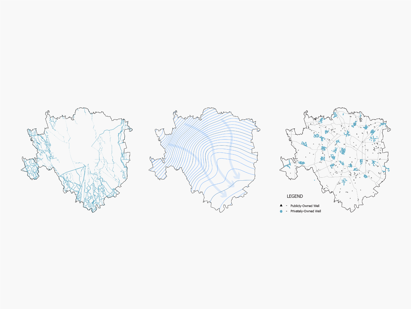
As mentioned previously, Milan was not built upon a major river course, a characteristic which makes it highly unique for a settlement which has grown to one of its size. Its location upon a plain directly below the Alps, amongst a dense network of watercourses means that the city benefits from a natural aquifer level of only a few metres below ground, providing an abundant supply of water for the city. As such, Milan and its surroundings have been characterised by the highest density of urban, industrial and agricultural activities in Italy, having found ways to use the water to its advantage.
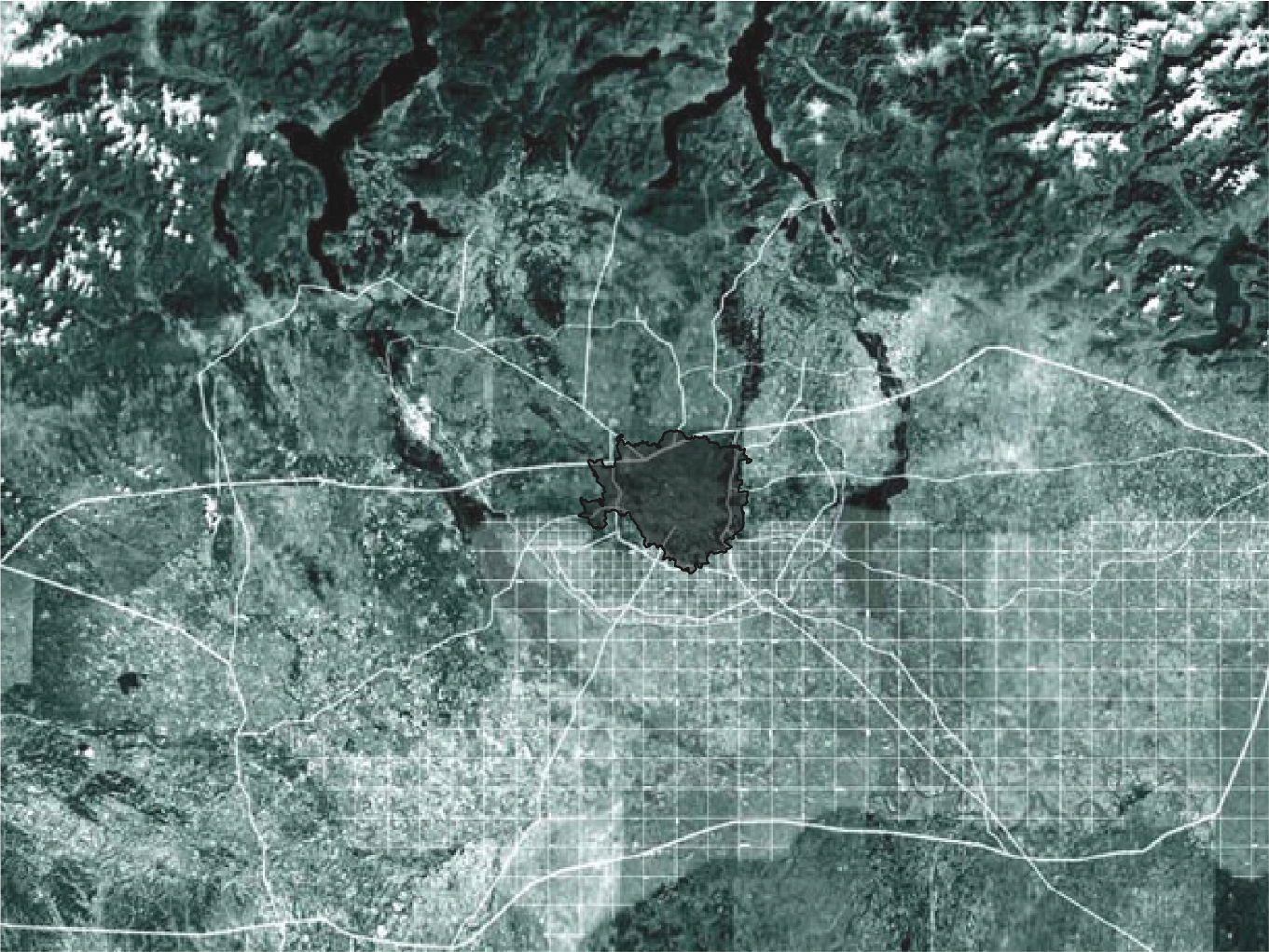
Satellite Location of the Milan Metropolitan Area upon the Po Plain
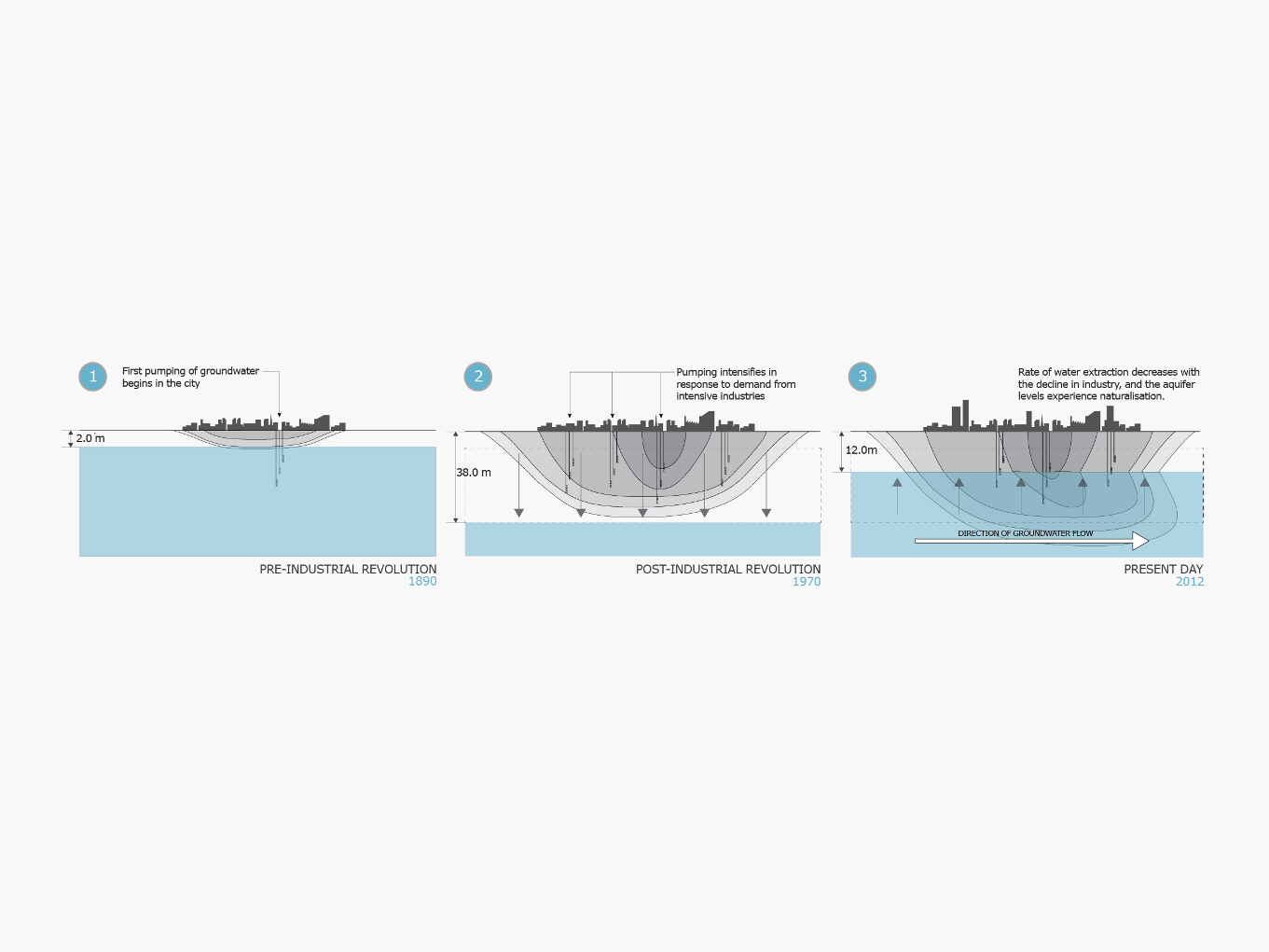
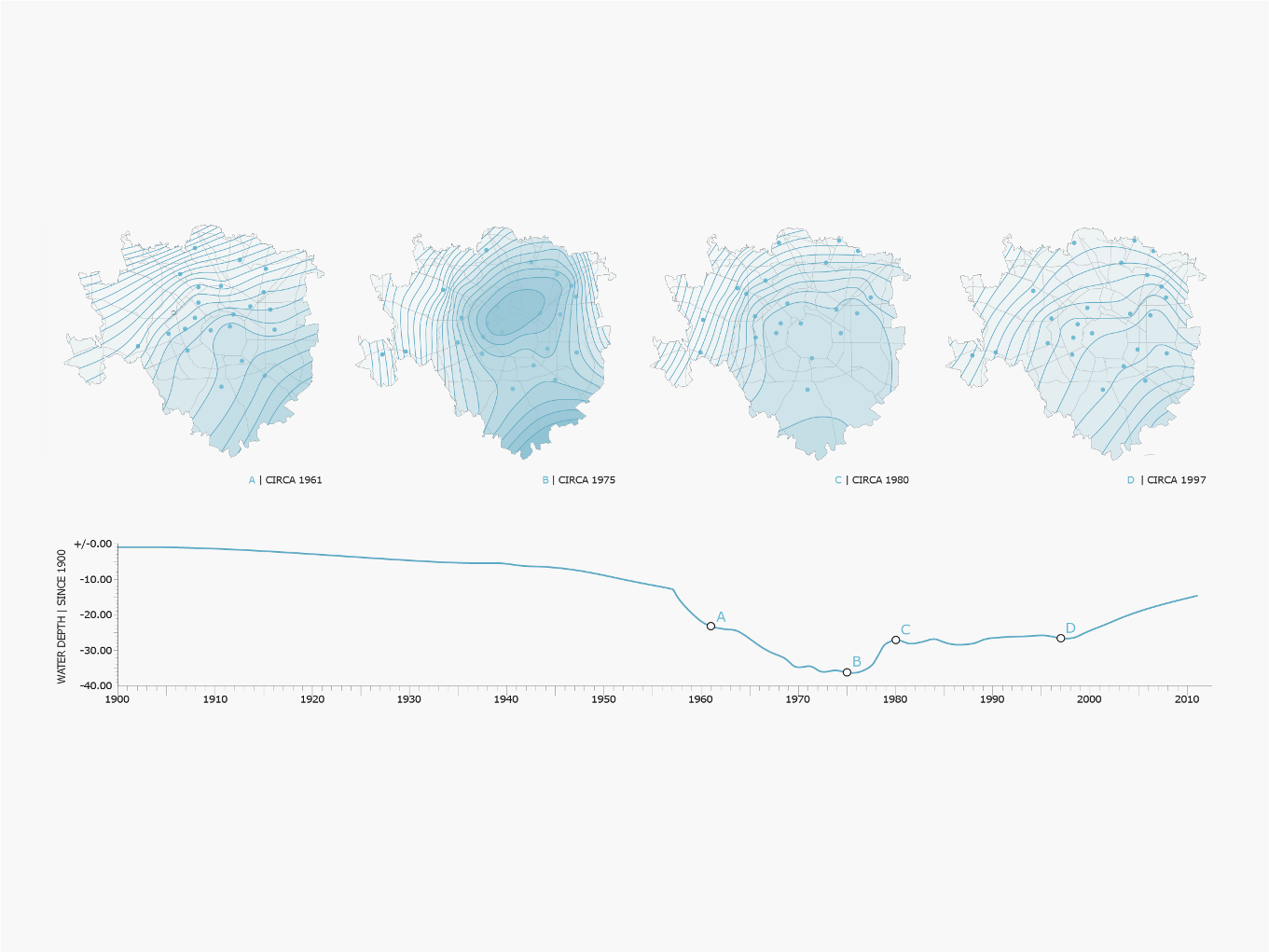
In 1915, the water table depth was recorded as being only one metre below the ground surface. During the 1970s, following decades of irresponsible extraction however, the piezometric level had dropped to a staggering 38m below ground level.

Milan Groundwater Evolution Maps and Graph
The decline in industry from the 1970s to the present day has fortunately allowed the natural aquifer to return to close to its natural levels. However, this ‘naturalisation’ now poses new problems, which unforeseen as the city expanded in the previous half a century. Two problems associated with the resurgence in the level of the aquifer are flooding as a result of groundwater, and local and diffuse contamination from the release of pollutants as soil become saturated once again.
As the city expanded through the second half of the previous century to accommodate an increasing urban population, the building of high-rise apartment blocks saw precedent over traditional housing types, and especially in the case of the city centre, the necessary excavation of land for sub-surface car parking, to accommodate an increasing reliance upon private transport. At the time of construction, the receded water table height posed no threat to the integrity of these buildings. However, as the water table begins to approach its former natural levels, the increased water presence now causes flooding in most sub-surface areas, from hospitals, to car parks, and even the lower levels of high-rise housing.
The need for detailed observation, management and responsive intervention of the water table through artificial means is now becoming increasingly apparent.
The recent rise in the water table following years of loss through intensive extraction not only poses problems of flooding in the underground spaces in the city, but also threatens natural ecosystems within the municipality of Milan. Since the 1970s, when industry was at its peak, a decline in contamination coinciding with the decline in industry has allowed previous contaminants to clear from the soil through the repeated filtration of rainfall. Many of the contaminants have reached groundwater sources and have been carried far beyond the region.
Surface Water Contamination of the Po Plain
Now local contaminants have resided in soil previously unsaturated with water, are now being slowly released back into local ecosystems as aquifer levels rise and soils become saturated once again. Pollutants, which were previously forgotten and posed no threat to the environment, now re-contaminate healthy ecosystems, threatening the local environment upon which the city depends for its food, and organisms which have fought to return to former habitats in the city.
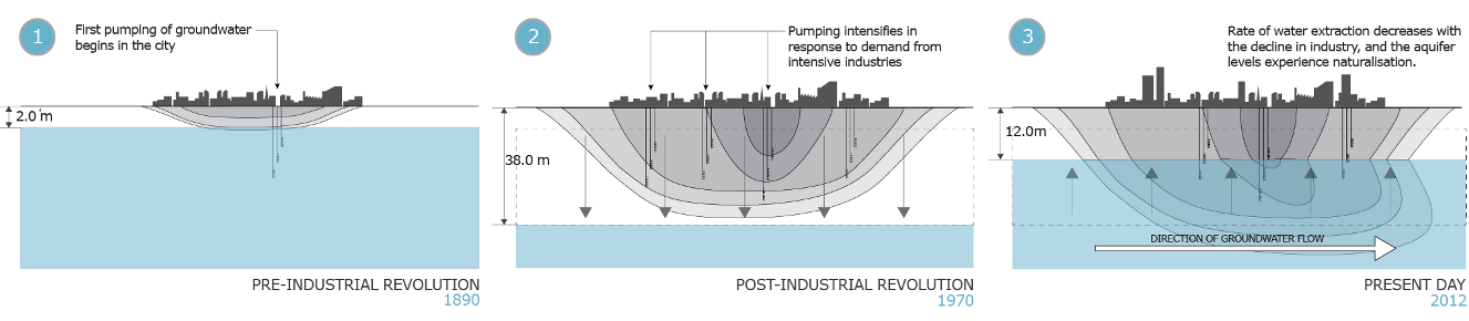
1) Pre-Industrial Revolution
Before the explosion of industry in the region, the natural aquifer level remained at a constant 2m below ground surface, making the land highly fertile, and suitable for the adoption of large-scale rice growing. Minimal contamination from everyday activities in the city posed no great threat to local ecosystems.
2) Post-Industrial Revolution
Irresponsible extraction of groundwater to feed industry intensifies until its peak in during the 1970s, causing the natural aquifer level to drop to staggering 33 metres below its natural level. The drying of the soil means that contaminants remained suspended in deeper soils.
3) Present Day
Pumping rates decrease with the decline in industry, causing a resurgence in the water table. The saturation of soil with water now releases contaminants which posed no previous threat, and the local environment sees an increase in contamination.
Re-Contamination of Milan Soils by Normalising Water Levels
As recent indications have shown, the continued ‘naturalisation’ of the water table following the decline in industrial activities, although welcomed in the more rural areas of the municipality, is causing untold damage to the sub-surface constructions in the city, and releasing formerly localised contaminants into the wider ecosystem, through the dense network of watercourses which surrounds the city.
Water Management Requirements – Four-Point Strategy
The responsible and sustainable extraction of subsurface water to be used within the city is now essential to prevent any further damage as a result of the resurgence in sub-surface water. In order to achieve this, a coherent management strategy, through extensive research and observation will be required to monitor hydrogeology in the municipal area, and assess and address contamination which has been released by the rising aquifer levels.
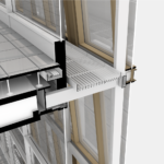
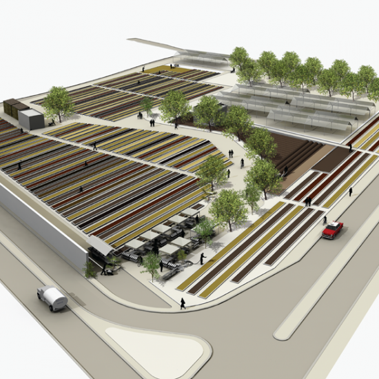
In order to implement a coherent strategy of water management, a new all-in-one facility combining a pumping station and research and observational facility will be located within the city limits, and will provide a centre through which all research pertaining to water consumption, contamination and remediation in the city, will be conducted.
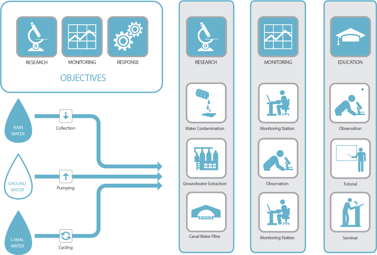
Hybrid Facility Water Management Concepts | Research Monitoring Education
By creating connections to prominent educational institutions within the city, such as the Bicocca University, and Politecnico di Milano, the centre will boast state of the art research facilities for use by universities, as well as city schools, to educate and co-ordinate valuable learning.
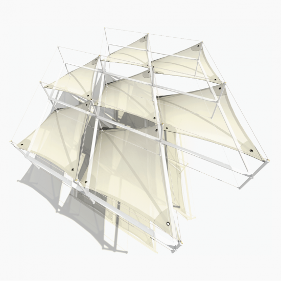
The Urban Agriculture & Community Food Centre is a theoretical project designed to respond simultaneously to these needs. The hybrid facility will combine research capabilities to tackle the three key underlying issues identified in the Urban Agriculture Masterplan: Brownfield contamination, Rising Groundwater Pressures, and diminishing food culture
Water Research Hybrid Facility | Three-Point Design Brief


Follow the links below to explore other similar, related projects