At the heart of the proposed Urban Agriculture Masterplan: Milan CPUL, the Urban Agriculture & Community Food Centre is tasked with overseeing the large-scale remediation and conversion of the land to intensive agriculture, and provide the necessary guidance and training to maximise the growing zones in an ecological way.
Echoing the themes of the Expo as well as the Italian-born Slow Food movement, the centre responds to the modern day issues of urban food production and distribution within the urban setting having learned from individually-successful and diverse building typologies from around the world.
Research analysed two successful contemporary urban food centres in Toronto, Canada and Milwaukee, US, which have built upon existing decaying urban infrastructure in contaminated brownfield to provide new community hubs, food production centres and decentralised food markets. The examples also address the persisting problems of unemployment in post-industrial cities.
The Milan Expo 2015 was envisaged on two themes: “Feeding the Planet, Energy for Life”- the need to explore new means to feed an exploding global urban population, and the ever-pertinent issue of Water, of which Milan suffers its own acute problems.
The modern day commercial capital of Italy and one of the most important cities during the country’s Industrial Revolution, was built upon a canal network that connected the city to the two main rivers of the Ticino and the Adda. This canal network, originally built as a means to transport agricultural produce and construction materials proved vital to the growth of the city, and provided a lifeline by which Milan was able to establish itself as a regional capital of trade and commerce, and grow to become one of Europe’s most important capitals of trade.
Although the canals nowadays have largely disappeared, paved over in the 1970s to provide an inner city ring-road, some remnants of the original network still remain. The Naviglio Grande, one of the two principal canals in Milan’s now reduced network, still connects the Ticino to the historic docks of the Darsena Basin, now a centre for night life in the city
Amongst the ambitious plans drawn up for the Milan Expo was a proposed scenic water route, the Via D’Acqua, which would connect the city centre to the new Expo site via the Naviglio Grande and a brand new canal connection. It is along this route, tapping into the new life of the Expo, that the site for a new Centre for Urban Agriculture is located.
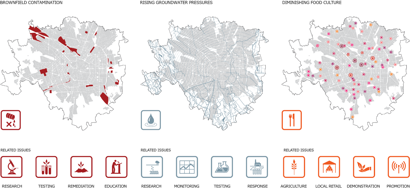
Contamination
As a former manufacturing base in the heart of one of the most industrious regions in Europe, Milan has suffered a similar fate to that of its industrial neighbours, with large areas of inner city land left abandoned following the downscaling of industry. Many of these areas suffer local contamination from the accumulation of common pollutants held suspended in the soil, preventing the regeneration of natural ecosystems in the unused areas, even decades after their closure.
The inherent costs of remediation deter developers from building on the land, and many sites remain vacant. The result is an industrial wasteland, devoid of natural capital which often becomes a target of vandalism and crime, which in turn impacts upon local land values, and perceptions of the inner city.

Rising Groundwater Pressures
In 1915, the water table depth was recorded as being only one metre below the ground surface- the natural piezometric level. However, following decades of intensive water extraction and consumption through the Twentieth century, peaking in the sixties and seventies, the water table fell to a staggering 40m below ground in some places.
The decline in industry from the 1970s to the present day has, fortunately, allowed the natural aquifer to return to close to its natural levels. However, this ‘naturalisation’ now poses new problems, which were not foreseen as the city expanded in the previous half a century. Two problems associated with the resurgence in the level of the aquifer include local and diffuse contamination from the release of pollutants which have been locked in the previously unsaturated soil, and the flooding of subsurface constructions as a result of groundwater surges.

Rising groundwater releases contamination locked in city soils
Diminishing Food Culture
Milan’s unwavering focus upon the future and its almost permanent state of reinvention has resulted in a loss of its local history, its customs and native traditions, as the global city increasingly looks to import culture from around the world. One such example is the loss of traditional food culture, as a result of imported easier, ‘faster’ foods from elsewhere in the continent. Deemed too time-intensive to prepare, Milan’s traditional, highly-nutritious rice and meat dishes, dairy products and confectionary are being replaced in city menus by southern Italian cuisine, pasta and pizza dishes, for their ease of preparation. In other areas, fast food is taking over, which leads to issues of sustainability of sourcing, and health problems.
However, the loss of local food culture represents an even greater loss for the city. The disappearance of local food culture signifies a lost connection between the people and the land, and with such a disconnect, newly-adopted global methods of food production and consumption bring new, unforeseen and damaging consequences for both the people and the land.
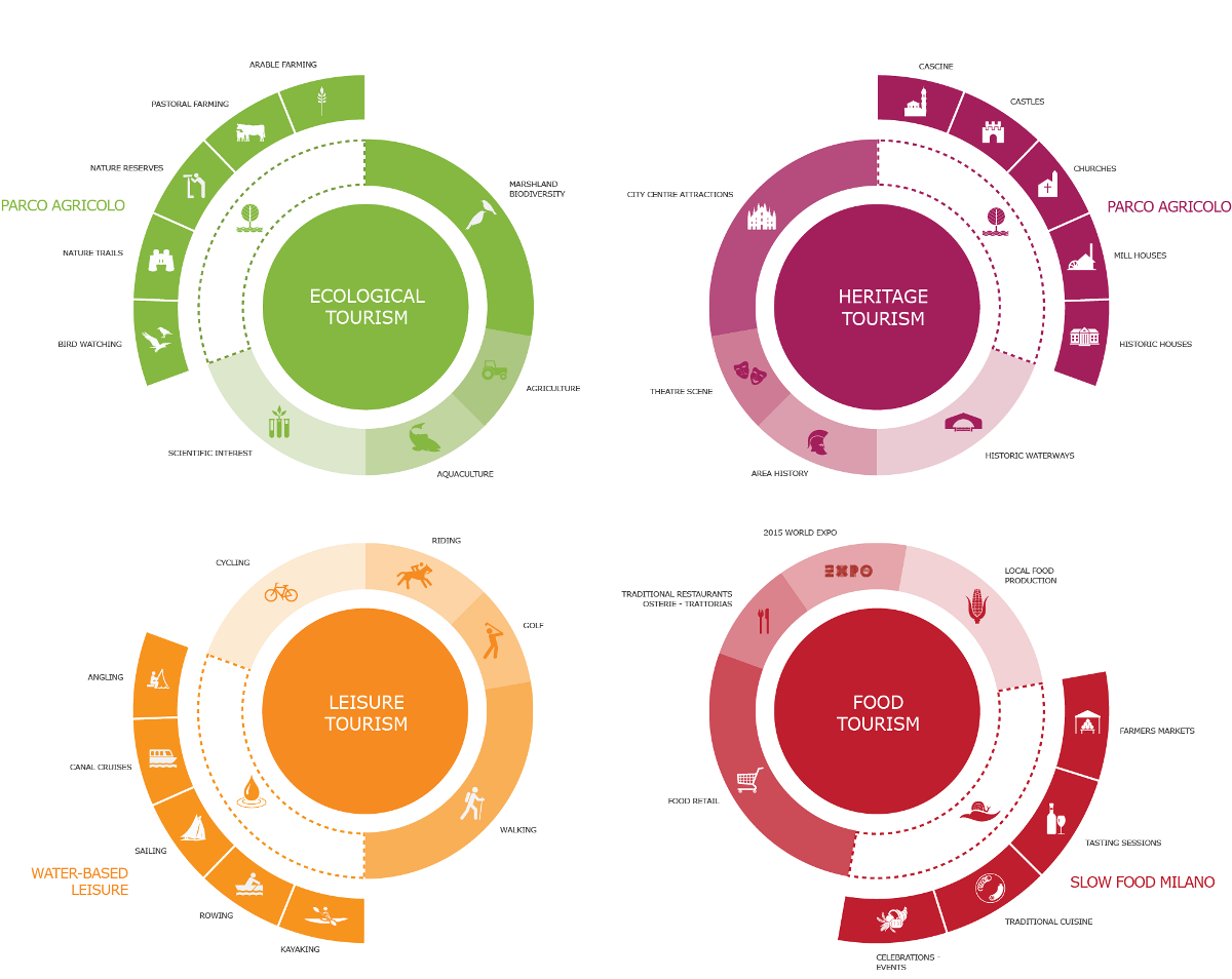
Located on the banks of the Naviglio Grande, the hybrid community centre comprises a research, educational, and commercial element to serve the south west of the city, as well as a centre for food-based tourism in the area.

Tourism Potential in the South-West of the City
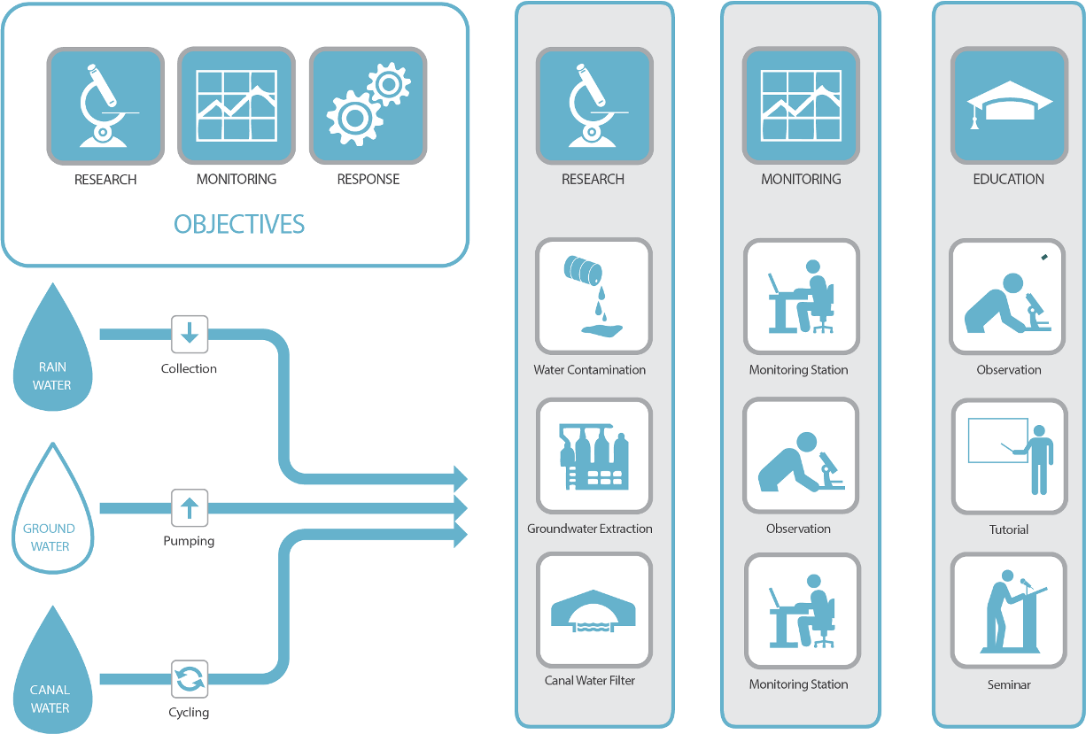
In order to implement a coherent strategy of water and land management in the city, a new hybrid research facility combining a pumping station and research and observational element will be located within the city limits, and will provide a centre through which all research pertaining to water consumption, contamination and remediation in the city, will be conducted. By creating connections to prominent educational institutions within the city, such as the Bicocca University, and Politecnico di Milano, the centre will boast state of the art research facilities for use by universities, as well as city schools, to educate and co-ordinate valuable learning.

Water Facility Concepts
At the heart of the greater Urban Agriculture Masterplan, the centre will oversee the remediation and conversion of the land to intensive agriculture, and provide the necessary guidance and training to maximise the growing zones in an ecological way. Demonstration gardens in the facility provide a means to educate and train members of the general public in how to establish new agriculture in the city.
A new thriving peri-urban agriculture movement in the southwest of the city will also require the emergence of new local food retail centres, where producers are able to distribute their produce to the local population, in a new sustainable model of food distribution.
The farmers’ market will provide a place for consumers to come in contact with local producers, providing an environment for local citizens to learn about all aspects of food production, and in doing so ‘reconnect’ the city and its people to the agricultural hinterland from which it has become disconnected.
Located at the centre of the southwest city masterplan, the new San Cristoforo Farmers’ Market will provide a new food retail centre which is easily accessible to both the local urban consumer population, and the producers in the south-western fringes of the city, through well-connected transport links.
New Transport Interchange
Follow the links below to explore other similar, related projects